Forgotten aerial photographs from 1937 reveal an anomaly in Antarctica
June 12, 2024
0
A study using long-forgotten aerial photographs of whalers from 1937 shows that ice in East Antarctica remains stable and even growing, despite some early signs of weakening. Extreme
A study using long-forgotten aerial photographs of whalers from 1937 shows that ice in East Antarctica remains stable and even growing, despite some early signs of weakening. Extreme weather conditions, melting glaciers and rising sea levels mean that the world’s climate and ice caps are in critical condition. But a new study from the University of Copenhagen’s Department of Earth Sciences and Natural Resource Management has found a positive anomaly.
By combining hundreds of old aerial photographs dating back to 1937 with modern computer technology, researchers tracked the evolution of glaciers in East Antarctica. Covering approximately 2,000 kilometers of coastline, this area contains as much ice as the entire Greenland ice sheet. Researchers identified glacier movement and size changes by comparing historic aerial photographs with modern satellite data and found that the ice has not only remained stable but has grown slightly over the past 85 years, due in part to increased snowfall.
“We keep hearing about climate change and new melting records, so it’s exciting to see a glacier field that has remained stable for almost a century,” says PhD student Mads Domgaard, first author of the study.
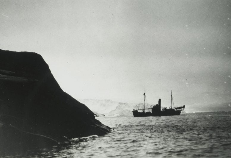
The whaling ship Firern carries the Stinson Reliant aircraft near Clarius Mikkelsen Fjell in the Lars Christensen District, East Antarctica. Credit Norwegian Polar Institute
Early signs of change
Despite the overall stability, the study also found the first signs of changes in the sea ice surrounding the glaciers; This suggests that these stable East Antarctic glaciers may shrink in the future.
“Our results also show that there is a degradation of sea ice, making the floating ice tongues of glaciers more vulnerable and failing to reach the extent seen in the first aerial photographs from 1937. The massive and accelerating melting we see in other parts of Antarctica, such as West Antarctica, is influenced by the ocean’s influence.” We know it plays a very important role,” says Domgaard.
hiding from the Nazis
Most of the footage used in the research was taken during an expedition organized and paid for by Norwegian whaler Lars Christensen in 1937. The aim of the mission was to produce the first maps of this part of East Antarctica, but the maps were never published due to the German occupation of Norway. Since then, the images have been stored and forgotten at the Norwegian Polar Institute in Tromsø.
When researchers from the University of Copenhagen read about the expedition, they realized that the valuable images were probably stored in an archive in Norway. They traveled to Tromsø and examined all 2,200 photographs taken during the expedition. They supplemented the Norwegian aerial photographs with images of the same glaciers obtained from surveys conducted in Australia between 1950 and 1974.
“By comparing historical aerial photographs with modern satellite data, we have obtained important information about glaciers that we would not have been able to obtain otherwise. Associate Professor Anders Björk from the University of Copenhagen, who led the group working on the historical images, said: “It is important to note that these old images can be used to generate new research results almost 100 years after they were taken.” “I think it’s great,” he says.
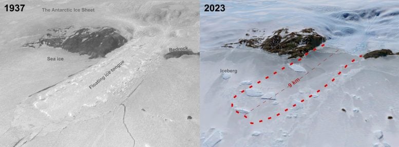
Comparison of the Honnerbrugga Glacier in Lützow Holm Bay in 1937 with a modern 2023 Landsat satellite image. The 9-kilometer-long floating tongue of ice seen in the 1937 photo disappeared in the late 1950s and did not grow back due to weakening sea ice. Credits: Mads Dømgaard / Norwegian Polar Institute
Possibility of rapid sea level rise
The Antarctic ice sheet is attracting increasing attention from researchers due to its potential for extremely large and rapid sea level rise. Unlike Greenland, little was known about Antarctica’s glaciers until the 1990s, when the first high-quality satellite observations became possible.
“Early observations of glaciers are extremely valuable because they give us a unique insight into how ice develops in a changing climate and whether current ice changes exceed the normal cycle of glacier advance and retreat,” explains Domgaard.
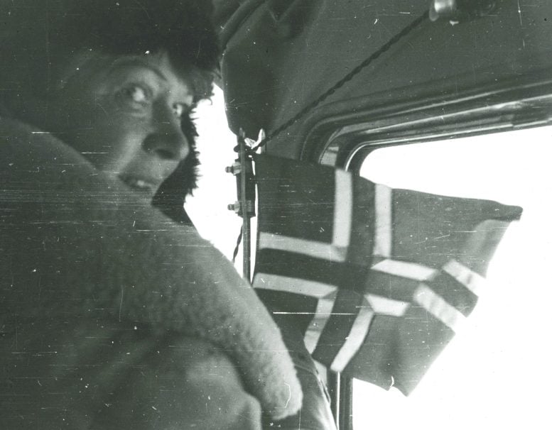
Lars Christensen’s wife, Ingrid Christensen, participated in several expeditions to Antarctica and is considered the first woman to set foot in Antarctica. Here he is seen on Stinson’s plane in 1937, ready to land the Norwegian flag in East Antarctica. Author: Norwegian Polar Institute
Improving predictive models
According to the researchers, reliable long-term data is crucial to making accurate predictions about the future evolution of glaciers and sea level rise, and this study provides new insights into the vast area of East Antarctica.
“Long-term glacier series improve our ability to create more accurate models of future ice changes because the models are trained on historical observations,” Björk concludes.
The findings were recently published Nature CommunicationIt is the result of a joint effort involving researchers from the University of Copenhagen, the Norwegian Polar Institute, the Norwegian Arctic University and the French Institute of Environmental Sciences.
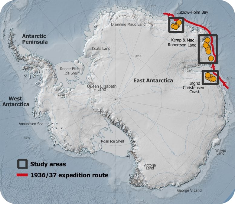
General map of the 1936/1937 expedition route and the areas explored by researchers. Image credit: Mads Dømgaard
More about the study
Of 2,200 photographs taken from seaplanes in 1937, 130 were selected for analysis.
Researchers combined historical photographs with modern satellite data to create a 3D reconstruction of the glaciers.
Added to the Norwegian aerial photographs were 165 aerial photographs of the same glaciers obtained from research conducted in Australia between 1950 and 1974. This allowed the researchers to examine the evolution of glaciers over different periods and calculate the historical ice flow rate for selected glaciers.
Compared to modern data, ice flow rates do not change. Although some glaciers thinned in shorter interim periods of 10 to 20 years, they remained stable or grew slightly over the long term, indicating the stability of the system.
As an experienced journalist and author, Mary has been reporting on the latest news and trends for over 5 years. With a passion for uncovering the stories behind the headlines, Mary has earned a reputation as a trusted voice in the world of journalism. Her writing style is insightful, engaging and thought-provoking, as she takes a deep dive into the most pressing issues of our time.