First high-resolution global color map of Mars created
September 3, 2024
0
In July 2020, China’s Tianwen-1 mission reached Mars orbit, consisting of six robotic elements: an orbiter, a lander, two deployed cameras, a remote camera, and a Zhurong rover.
In July 2020, China’s Tianwen-1 mission reached Mars orbit, consisting of six robotic elements: an orbiter, a lander, two deployed cameras, a remote camera, and a Zhurong rover.
The mission, the first in a series of interplanetary missions carried out by the China National Space Administration (CNSA), aims to study the geology and interior of Mars, characterize its atmosphere and search for signs of water on Mars.
Like many orbiters, landers, and rovers currently exploring Mars, Tianwen-1 is searching for possible evidence of life (past and present) on Mars.
During the approximately 1,298 days that the Tianwen-1 mission explored Mars, the orbiter acquired countless remote-sensing images of the Martian surface. Thanks to a team of researchers from the Chinese Academy of Sciences (CAS), these images were combined to create the first high-resolution global color map of Mars with a spatial resolution of more than 1 km (0.62 mi). It is currently the highest-resolution map of Mars and could one day serve as a global base map to support human missions.
The team was led by Professor Li Chunlai from the National Astronomical Observatory of China (NOAC) and Professor Zhang Rongqiao from the Lunar and Space Exploration Center. They were joined by numerous colleagues from the Key Laboratory of Lunar and Deep Space Exploration, the Institute of Optics and Electronics, University of Chinese Academy of Sciences, and Shanghai Institute of Physics. A paper detailing their research, “Tianwen-1 Global Pixel-Per-76m Color Image Set and Mars Map,” was recently published in the journal Science Bulletin.
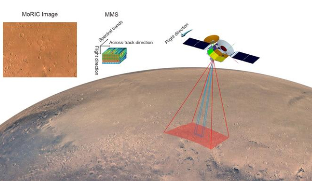
The Optical Camera (MoRIC) and Imaging Spectrometer (MMS) on the Tianwen-1 orbiter were used to obtain remote sensing images of the entire surface of Mars.
Various global maps of Mars have been created using remote sensing images obtained by instruments on six previous missions. These include the visual imaging systems on the Mariner 9 probe, the Viking 1 and 2 orbiters, the Mars Orbiter Camera Wide Angle (MOC-WA) on Mars Global Surveyor (MGS), and the Content Camera (CTX) on the Mars Reconnaissance Orbiter (MRO), Mars Express (MEX) High Resolution Stereo Camera (HRSC) and Mars Odyssey Orbiter Thermal Imaging System (THEMIS).
However, all of these maps had a much lower spatial resolution than what the CAS team produced using images obtained by the Tianwen-1 orbiter. For example, the MGS MOC-WA Atlas Mosaic has a spatial resolution of 232 meters per pixel (280 yards per pixel) in the visible range, and the Mars Odyssey mission’s THEMIS Global Mosaic offers a spatial resolution of about 100 m/pixel (~110 ft/pixel) in the infrared. The MRO Global CTX Mosaic of Mars covers 99.5% of the visible Martian surface (88°N to 88°S), but has a spatial resolution of about 5 m/pixel (5.5 yd/pixel).
Global color images of Mars with spatial resolution of one hundred meters (110 yd) or better were also lacking. For global color images, the Mars Viking Colorized Global Mosaic v1 and v2 have spatial resolutions of approximately 925 m/pixel and 232 m/pixel (~1010 and 255 yd/pixel), respectively.
Simultaneously, the MoRIC instrument acquired 14,757 images with spatial resolutions ranging from 57 to 197 m (62 and 215 yd) during more than 284 orbits of the Tianwen-1 orbiter.
At the same time, the Tianwen-1 Mars Mineralogical Spectrometer obtained a total of 325 bands of visible and near-infrared data with a spatial resolution of 265 to 800 m (290 to 875 yd).
The collected images also provided global coverage of the Martian surface. Using this data, Professor Li Chunlai, Professor Zhang Rongqiao and their colleagues processed the image data, resulting in the latest global map of Mars. The team also optimized the output of the orbit measurement using coupling correction technology. By treating Mars as a single correction grid, the team was able to reduce the position deviation between individual images to less than one pixel, creating a “seamless” global mosaic.
True colors of the Martian surface were captured with MMS data, while color correction provided global color uniformity. This resulted in the launch of the Tianwen-1 Mars Global Color Orthomosaic 76 m v1 with a spatial resolution of 76 m (83 yd) and horizontal accuracy of 68 m (74 yd).
This map is currently the highest-resolution global map of Mars in true color, greatly improving the resolution and color fidelity of previous Mars maps.
This map could serve as a geographic reference for other space agencies and partner organizations to map the Martian surface in higher resolution and detail. It could also be used by space agencies to select locations for future robotic explorers that will continue to search for clues about Mars’ past.
As an experienced journalist and author, Mary has been reporting on the latest news and trends for over 5 years. With a passion for uncovering the stories behind the headlines, Mary has earned a reputation as a trusted voice in the world of journalism. Her writing style is insightful, engaging and thought-provoking, as she takes a deep dive into the most pressing issues of our time.