NASA satellites map the damage caused by the earthquake in Turkey
February 13, 2023
0
Scientists from NASA and other institutions are using satellites to map the damage caused by the devastating earthquake in the Republic of Turkey. On February 6, 2023, two
Scientists from NASA and other institutions are using satellites to map the damage caused by the devastating earthquake in the Republic of Turkey. On February 6, 2023, two 7.8 and 7.5 magnitude earthquakes struck southern Turkey and western Syria, causing widespread destruction in both countries.
The first earthquake occurred along a fault line located 18 kilometers (11 miles) below the surface and produced a powerful tremor that affected a large radius from the epicenter. The first quake was followed nine hours later by another powerful 7.5 magnitude earthquake and hundreds of small aftershocks. In response to news of the disaster, scientists from space agencies around the world, including NASA, took action, analyzing satellite data to better understand the event.
“These were very strong, powerful earthquakes that ran from a long series of fault segments to the surface,” said Eric Fielding, a geophysicist at NASA’s Jet Propulsion Laboratory (JPL). “It caused extremely strong tremors over a very large area that affected many cities and towns filled with people. The length of the rupture and the magnitude of the 7.8 magnitude earthquake were similar to the 1906 earthquake that destroyed San Francisco.”
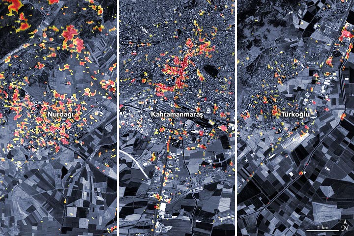
This image shows in detail the regions highlighted on the map above: the cities of Nurdağı, Kahramanmaraş and Türkoğlu.
The preliminary damage representative map above shows some parts of Türkoğlu, Kahramanmaraş and Nurdağı provinces. Dark red pixels indicate areas or landscape changes likely to have severe damage to buildings, homes and infrastructure, while orange and yellow areas are moderately or partially damaged. Each pixel is approximately 30 meters wide (about the size of a baseball field).
The map is based on data collected by PALSAR-2 aboard the Advanced Land Observation Satellite-2 (ALOS-2) on February 8, 2023. The satellite contains synthetic aperture radar, a sensor that sends microwave pulses to the Earth’s surface and listens for the reflections of these waves to map the landscape, including buildings. By comparing the February 8 data with observations made by the same satellite before the earthquake (April 7, 2021 and April 6, 2022), scientists tracked the changes and began to identify damaged areas. ALOS-2 data was provided by Sentinel Asia and analyzed by the Singapore Earth Observatory – Remote Sensing Laboratory in collaboration with NASA’s Jet Propulsion Laboratory and the California Institute of Technology.
“The map covers only the central part of the affected area due to the narrow 70-kilometer strip of ALOS-2 thin beam data, but includes the epicenters of both the 7.8 main earthquake and 7.5 aftershocks,” Fielding said. Said. “Note that the time intervals between ALOS-2 acquisitions are up to one year, so the accuracy of the damage proxy map may be lower in areas with vegetation, such as mountains, due to seasonal changes.” Some areas marked as damaged in vegetated areas may not be damaged, while some areas that are not damaged in vegetated areas may be damaged.
Members of NASA’s Applied Earth Sciences Division Disaster Program and their national and international collaborators are in the process of sharing the damage proxy map and the data used to create it with organizations such as the US Department of State, the California Seismic Safety Commission, Miyamoto Global. Disaster Relief and the World Bank. The team also participates in ongoing calls for coordination organized by USAID to assess the needs of stakeholders in the region and provide scientific expertise to support risk assessments and recovery efforts.
“We’re watching this incident closely,” said program manager Shanna McClain. “In addition to mapping the damage as much as possible via satellites, we use satellites to monitor the increased risks of landslides, power outages and weather conditions that could be a challenge for response.”
As an experienced journalist and author, Mary has been reporting on the latest news and trends for over 5 years. With a passion for uncovering the stories behind the headlines, Mary has earned a reputation as a trusted voice in the world of journalism. Her writing style is insightful, engaging and thought-provoking, as she takes a deep dive into the most pressing issues of our time.