Scientists have revealed the most detailed geological model of the Earth in the last 100 million years.
March 4, 2023
0
The Earth’s surface is the “living skin” of our planet – it connects the physical, chemical and biological systems. Over geological time, landscapes change as this surface develops,
The Earth’s surface is the “living skin” of our planet – it connects the physical, chemical and biological systems. Over geological time, landscapes change as this surface develops, regulating the carbon cycle and nutrient cycle as rivers carry sediment into the oceans. All of these interactions have far-reaching consequences for ecosystems and biodiversity – the many creatures that inhabit our planet.
Therefore, reconstructing how Earth’s landscapes have evolved over millions of years is a fundamental step towards understanding the changing shape of our planet and the interaction of things like climate and tectonics. It can also give us clues about the evolution of biodiversity. Our team from the University of Sydney, working with scientists in France (the French National Center for Scientific Research, ENS Paris University, the University of Grenoble and the University of Lyon), has published a detailed geological model of Earth’s surface changes in a prestigious journal. science.
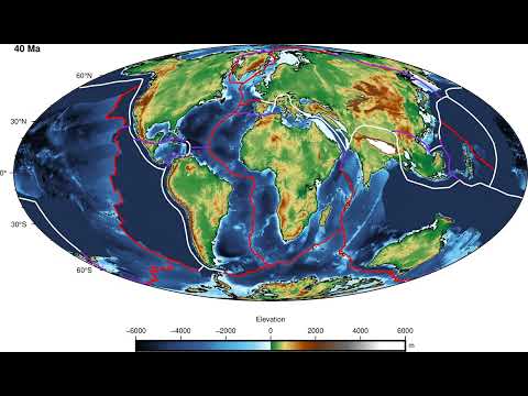
Our first dynamic model is a high-resolution computer simulation of the last 100 million years, up to 10 kilometers (6.2 miles). It shows, in unprecedented detail, how the Earth’s surface has changed over time and how this affects the way sediment moves and settles. Divided into frameworks over millions of years, our model is based on a framework that combines plate tectonics and climate forces with surface processes such as earthquakes, weathering, river changes, and more.
three years of study
The project started about three years ago when we started developing a new model of global landscape evolution that could simulate millions of years of change. We’ve also found ways to automatically add other information to our framework, such as paleogeography (the history of Earth’s landscapes). Our framework for this new study used state-of-the-art plate tectonics reconstructions and past climate simulations on a global scale.
Our advanced computer simulations used Australia’s national computing infrastructure running on hundreds of computer processors. Each simulation took several days and created a complete picture to reconstruct the evolution of the Earth’s surface over the last 100 million years. All this computational power has resulted in high-resolution global maps showing the highest and lowest points of Earth’s landscapes (elevation), as well as water and sediment flows.
All this is in good agreement with current geological observations. For example, we combined data on modern river sediments and water flows, drainage basin areas, seismic surveys, and long-term local and global erosion trends. Our main results are available as time-based global maps at five million-year intervals from the Open Science Framework.
As an experienced journalist and author, Mary has been reporting on the latest news and trends for over 5 years. With a passion for uncovering the stories behind the headlines, Mary has earned a reputation as a trusted voice in the world of journalism. Her writing style is insightful, engaging and thought-provoking, as she takes a deep dive into the most pressing issues of our time.