China’s Mars rover discovers underground geometric shapes for the first time
November 30, 2023
0
China’s Zhurong rover was equipped with a ground-penetrating radar system that allowed it to peer beneath the Martian surface. Researchers announced new results by scanning Zhurong’s landing site
China’s Zhurong rover was equipped with a ground-penetrating radar system that allowed it to peer beneath the Martian surface. Researchers announced new results by scanning Zhurong’s landing site on the Utopia Plain, saying they found irregular polygonal wedges along the robot’s path at a depth of about 35 meters.
The sizes of the objects vary from centimeters to tens of meters. Scientists believe the embedded polygons formed billions of years ago as a result of freeze-thaw cycles on Mars; but they may also be volcanic, the result of cooling lava flows.
The Zhurong rover landed on Mars on May 15, 2021, making China the second country to successfully land a rover on Mars. The cute rover, named after the Chinese god of fire, surveyed the landing site, sent back photos (including a selfie taken with the lander via the remote camera), examined the topography of Mars, and took measurements with a ground-penetrating radar (GPR). ) instrument.
Zhurong’s primary mission lifespan was three Earth months, but it operated successfully for just over one Earth year before entering a planned hibernation. However, there has been no news from the traveler since May 2022.
Researchers from the Institute of Geology and Geophysics of the Chinese Academy of Sciences, who worked with Zhurong’s data, said GPR provides an important complement to orbital radar studies with missions such as ESA’s Mars Express and China’s own Tianwen-1 orbiter.
They noted that in situ GPR imaging could provide significant local detail of shallow structures and composition at depths of approximately 100 meters throughout the rover’s passage.
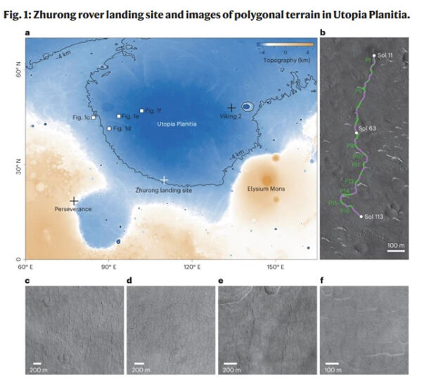
Topographic map of Utopia Planitia (a) showing the landing sites of the Zhurong rover, the Viking 2 lander, and the Perseverance rover. Four local areas with polygonal topography (c–f) are marked with white squares
Utopia Planitia is a large plain within Utopia that is the largest known impact basin on Mars (as well as in the Solar System), with an estimated diameter of 3,300 km. The rover has traveled a total of 1,921 meters throughout its existence.
The rover’s radar detected sixteen polygonal slices about 1.2 kilometers apart, indicating that similar terrains are widely distributed beneath Utopia Planitia, researchers led by Lei Zhang wrote in their paper published in the journal Nature.
These discovered features likely formed 3.7-2.9 billion years ago during the Late Hesperian-Early Amazonian period on Mars, “perhaps with the end of the ancient humid environment.” The paleo-polygonal terrain, whether eroded or not, was then buried.’ Later geological processes.
Although polygon-type terrain has been observed in various parts of Mars during many previous missions, this is the first time signs of hidden polygonal objects have been detected.
The embedded polygonal landscape requires a cold environment, which may be related to the freezing and thawing of water/ice in the southern part of the Utopian Plain on early Mars, the researchers write.
“The possible presence of water and ice necessary for the freeze-thaw process in the wedges may have resulted from migration of moisture caused by cryogenic absorption from an underground aquifer on Mars, from airborne snowfall, or from vapor diffusion to deposit pore ice,” the paper states. states. explains
Previous studies of Zhurong’s radar data showed that multiple floods occurring during the same time period created several layers beneath Utopia Planitia’s surface.
Although the new paper suggests that the most likely formation mechanism would be soil compression by wet sediments that dry to form mud cracks, compression by cooling lava may also have caused thermal compression cracking.
In any case, they note that a major change in the Martian climate was responsible for the formation of the polygon.
“The structure of the subsurface, together with the covering materials covering the buried paleo-polygonal terrain, suggests that a significant paleoclimatic transformation occurred sometime thereafter,” the researchers write.
“The contrast above and below the depth of about 35 meters is a marked transformation in water activity or thermal conditions in ancient Martian time, implying that a climate change occurred in low and mid-latitudes.”
As an experienced journalist and author, Mary has been reporting on the latest news and trends for over 5 years. With a passion for uncovering the stories behind the headlines, Mary has earned a reputation as a trusted voice in the world of journalism. Her writing style is insightful, engaging and thought-provoking, as she takes a deep dive into the most pressing issues of our time.