The lost continent of Atlantis may have been home to half a million people 70,000 years ago
January 17, 2024
0
About 70,000 years ago, the vast expanse of land now submerged off the coast of Australia could once have supported a population of half a million people. The
About 70,000 years ago, the vast expanse of land now submerged off the coast of Australia could once have supported a population of half a million people. The underwater area was so large that it could have served as a stepping stone for migration from modern-day Indonesia to Australia, according to the results of a new study published Dec. 15 in the journal Quaternary Science Reviews.
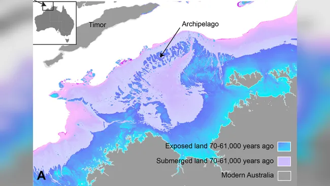
“Today we are talking about a landscape that is quite submerged, over 100 meters deep. [330 футів] “below sea level,” Kasih Norman, an archaeologist at Griffith University in Queensland, Australia, and lead author of the new study, told LiveScience. This Australian “Atlantis”, while above sea level, encompassed a large area of continental shelf connecting the Kimberley and Arnhem Land regions, which are today separated by a large oceanic gulf.
Scientists have discovered a lost landmass off the coast of Australia that could hold up to half a million people. (Image: Carly Rosengrin/Griffith University)
This ancient large Australian landmass was once part of a paleocontinent that connected modern Australia, New Guinea and Tasmania into a single unit known as Sahul.
Despite its scale, little research has been done on whether humans could live on the now-submerged shelf. “There was an assumption in Australia that our continental margins were probably unproductive and unused by humans, even though there was evidence from many parts of the world that people had certainly been on these continental shelves in the past,” Norman said.
His new research turns this assumption on its head. It provides detailed maps of seafloor features from the submerged continental shelf, obtained using sonar maps from ships, as well as regional data on sea levels between 70,000 and 9,000 years ago. This combination painted a picture of dramatically changing conditions on this shelf over the course of the study.
First, the data showed that between 71,000 and 59,000 years ago, sea level was about 40 meters lower than it is today, revealing a curved island chain at the outer northwestern tip of the Australian continent. This archipelago was located not far from the Southeast Asian island of Timor, not far from Indonesia.
Then, between 29,000 and 14,000 years ago, there was another sharp drop in sea level, coinciding with the peak of the last ice age. This was a period when sea levels fell further as large amounts of water froze into ice. These sharp drops in levels exposed a large portion of the continental shelf immediately adjacent to modern-day Australia. “We’re really looking at a landmass about 1.6 times the size of England,” Norman said.
This, combined with the previously discovered island ring, “would mean that there was a continuous archipelagic environment moving from the Indonesian archipelago to Sahul and then from that archipelago towards the supercontinent,” Norman said. This may have caused what he calls a “progressive migration” between present-day Indonesia and Australia.
Meanwhile, sonar mapping has revealed a landscape where humans could easily thrive: a high, sheltered hillside containing an inland sea adjacent to a large freshwater lake. There was also evidence of meandering riverbeds carved into the ground.
Norman estimated that a large shelf with such life-sustaining features could house between 50,000 and half a million people. “It’s important to keep in mind that we’re not talking about actual population; it’s just a matter of estimating the carrying capacity of our land,” he said. “We’re actually saying that’s how many people could be there.”
Withdrawal and migration
But other studies show that this once-open plateau was indeed home to hundreds of thousands of people. Ironically, they come from a time when potential inhabitants of this Atlantis would be challenged by the rising tides from their new land.
As the last ice age began to wane, melting glaciers poured water into rising seas. About 14,000 to 14,500 years ago, sea level rose at a rate ranging from about 3.2 feet (1 m) to one meter per year. [ 3,2 фута] From 100 years to 16 feet. “More than 100,000 square kilometers of land were flooded during this 400-year period,” Norman said. Between 12,000 and 9,000 years ago this happened again, and another 100,000 square kilometers were swallowed by the sea. “People will actually see the landscape change in front of them and they will quickly be pushed to the front of the shoreline,” Norman said.
This hypothesis is supported by other studies. A study recently published in the journal Nature analyzed the genetics of people living on the Tiwi Islands, which today lie at the edge of the shelf. Changes in genetic characteristics were found at the end of the last ice age, indicating an influx of new populations. At most around 14,000 years ago, and then between 12,000 and 9,000 years ago, the archaeological record on the fringes of modern Australia shows an increase in stone tool deposits; this is often interpreted as the sudden appearance of many more people in this area. ” said Norman.
Cave art in the Kimberley and Arnhem Land around this time also changed to include new styles and subjects, including more human figures. Norman said this may be due to new people coming to the area.
He hopes his research will encourage others to pay more attention to the archaeological significance of Australia’s submerged continental shelf.
“It is fascinating to see how dynamically people responded to past events and clearly survived and thrived. “Hopefully we can take something away from this that we can apply to future climate change and sea level rise over the next few hundred years.”
As an experienced journalist and author, Mary has been reporting on the latest news and trends for over 5 years. With a passion for uncovering the stories behind the headlines, Mary has earned a reputation as a trusted voice in the world of journalism. Her writing style is insightful, engaging and thought-provoking, as she takes a deep dive into the most pressing issues of our time.


")


