Extremely low ice level in Great Lakes sets record
- February 19, 2023
- 0
The Great Lakes have been remarkably ice-free this winter. In fact, as of February 14, 2023, ice covered only 6.6 percent of the five freshwater lakes. That’s significantly
The Great Lakes have been remarkably ice-free this winter. In fact, as of February 14, 2023, ice covered only 6.6 percent of the five freshwater lakes. That’s significantly

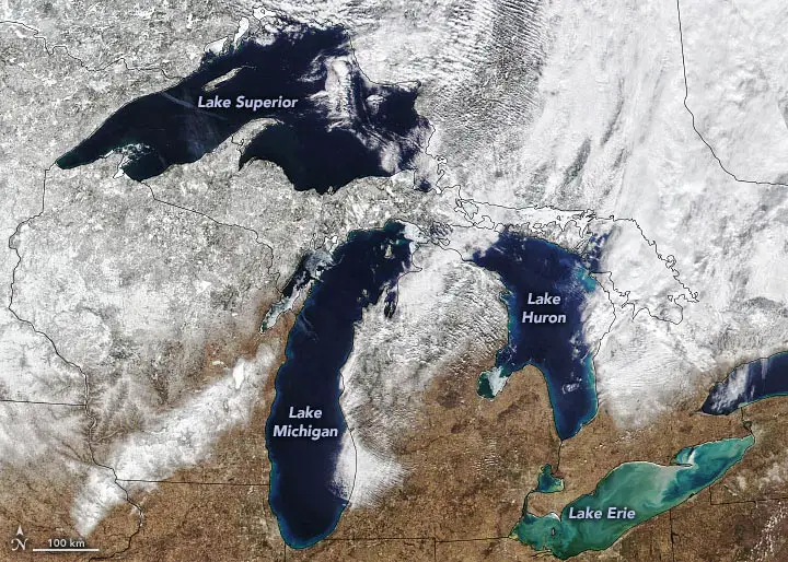
The Great Lakes have been remarkably ice-free this winter. In fact, as of February 14, 2023, ice covered only 6.6 percent of the five freshwater lakes. That’s significantly less than the 35-40 percent ice cover typical of mid-February, according to data released by NOAA’s Great Lakes Environmental Research Laboratory (GLERL).
The lakes had 7 percent ice cover when the Visible Infrared Imaging Radiometer Suite (VIIRS) instrument on the NOAA-20 satellite acquired this image on February 13. This is the lowest amount of ice measured on this day of any year since satellite records began in 1973. A small amount of ice covers the shores of the lakes. An ice strip can be seen crossing Lake Huron’s Saginaw Bay. In Lake Erie, swirls of sediment raised by storms give the water a marbled appearance.

Air temperature is the main factor influencing ice cover in the Great Lakes. Air temperatures in each of the five lakes were above average in January 2023, according to the U.S. National Ice Center. According to NOAA, the average temperature in the US was 35.2 degrees Fahrenheit (5.1 degrees above average), making January 2023 the sixth warmest January on record.
Ice cover in the Great Lakes basin briefly jumped to 21 percent in early February in response to the sharp cold. But it has since declined, at least until mid-February. Maximum ice cover usually occurs from mid-February to early March.
The ice cover on the lakes changes from year to year. But an analysis conducted by Jia Wang, an ice conditioning specialist at NOAA’s GLERL, shows a downward trend spanning 44 years. During the winter period from December 1 to April 30, average ice cover on the Great Lakes decreased by 69 percent between 1973 and 2017.
Human-induced warming played a role in this decades-long decline. But Wang found that a larger factor is the natural patterns of climate variability over the Pacific and Atlantic oceans: the North Atlantic Oscillation, the Atlantic Multidecadal Oscillation, the Pacific Decadal Oscillation, and the El Niño-Southern Oscillation.
“We have to look at these four patterns each year to model the ice sheet,” Wang said. “Now, the Pacific Decadal Oscillation is causing the Great Lakes to warm along with the North Atlantic.”
Source: Port Altele
As an experienced journalist and author, Mary has been reporting on the latest news and trends for over 5 years. With a passion for uncovering the stories behind the headlines, Mary has earned a reputation as a trusted voice in the world of journalism. Her writing style is insightful, engaging and thought-provoking, as she takes a deep dive into the most pressing issues of our time.